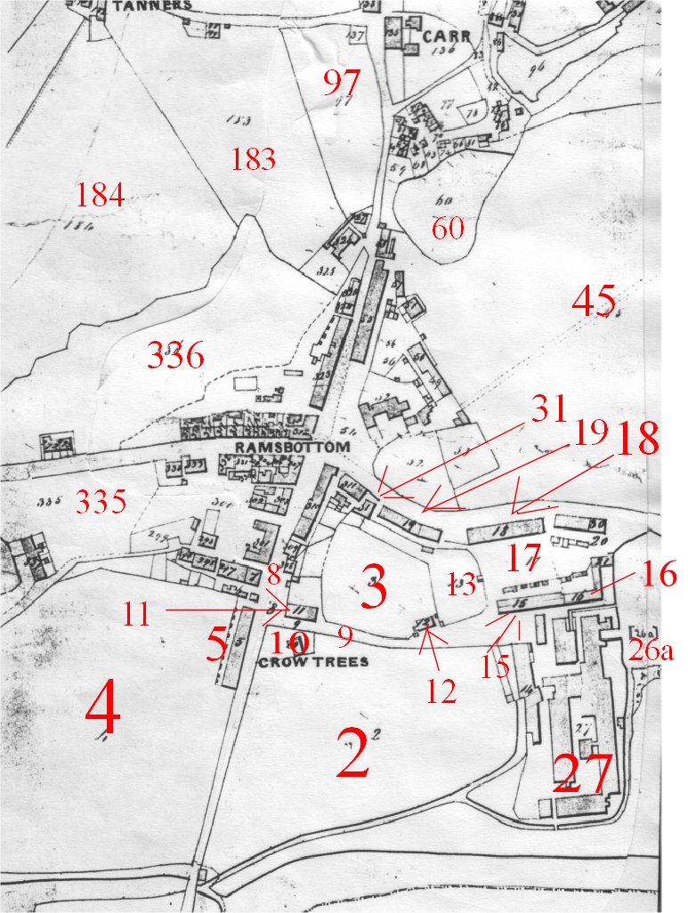
EXTRACTS FROM THE TITHE AWARD SCHEDULE
Map number M01
Click on the map for a larger view
This map is from 1842 and the table below shows who owned which land and property. Crow Lane is Number 9 on the Map just above Crow Trees Farm ( Now St Paul's Church)
Occupiers No Description Comment
 Owners:
Samuel Ashton & Brothers               
                                                                                         
CROW TREES OR LOWER RAMSBOTTOM
Richard
Schofield                   
1               
Great and Lower Eaves
(Meadow)                   
Extended to Stubbins boundary                


9
named occupiers                
5               
Cottages & Yards                  
  
                        
‘Dungeon Row’ 
Road                       
               
8               
Road                                       
  
            Water Street
- old name of top end of Bridge Street                                                                                                                   
12
named occupiers               
16               
Cottages garden & Road                               
Return Street
LOWER RAMSBOTTOM
Samuel
Ashton & Brothers       26a               
Goit Embankment & 
Reservoir                      
            This
lodge extended some 200 yards alongside
Stubbins Lane
                               
                   
27               
Spinning & Weaving
Manufactory              
        Ramsbottom Mill
Owners: Samuel Ashton & Thomas
Elton
Richard Schofield               
    2               
Rookery Field (Arable)         
                    
Site of St Paul’s Church
                               
               
 3               
Carr Bank (Pasture)
               
  
             Site of
St Paul’s school                         
Road                                       
9               
Road       
                               
               
    Now Crow Lane
Richard
Schofield               
  10               
Farmhouse & Garden                             
Crow-trees farm                              
11 Barn Stable Site of modern chapel of rest
Thomas Lord } 12 Cottages & Yard Still exist as 27, Crow Lane
Robert Hopkinson }
Richard Schofield 13 Garden
13
named occupiers               
15               
Cottages & Backyards                          
Return Street
Unoccupied                            
 17               
Road & Waste                     
               
  Factory Street
22
named occupiers               
18               
Cottages Building                                   
Back to back terrace known as
 
& 1 unoccupied                    
                     
Land & Road                       
               
  ‘Irish Row’
16
named occupiers               
19               
Cottages                                 
             
Back to backs - ‘Wesleyan Row’
Owners: Samuel Ashton & Brothers & Samuel Ashton & Thomas Elton
Richard
Schofield                    
 4               
Great Meadow (Pasture)
Owners: Samuel Ashton & Brothers &
William Grant & Brothers               
                               
               
`              
                              
                  
6               
Private Lock up or Prison                
Origin of name ‘Dungeon Row’,                      


 which was just to its south 
Owners: Samuel Whittaker & others Trustees of
the Wesleyan Methodist Chapel and School                                                                                                                                                                                                                   
                               
                
31               
Chapel & School                    
        Christ Church Methodist Chapel
Owners: William Grant & Brothers
CARR BARN
James
Barker         
               
45               
Chapel field (Pasture)
3
occupiers                            
49               
Cottages & yard                    
            Peel
Street
8
occupiers                            
50               
Cottages & Road                   
           Peel
Street
3
occupiers                            
51               
Cottages garden & Road        
George
Goodrick                    
52               
Grant Arms Inn Outbuildings
                                                               
  Yards Roads Piggaries [sic]
                                                               
  & garden
                               
               
53               
Bowling Green
Unoccupied                            
54               
Building land & waste                          
Now Market Place
 
Occupiers No Description
21 named occupiers 55 Cottages and back yards ‘Higher New Row’ in 1834 Rate
 
& 1 empty             
                               
School & Road                       
             
Book - on Carr Street
4
occupiers                            
57               
Cottages & Waste
MAYBROOK [presumably MAGBROOK]
Richard
Aspinwall               
58               
Spinning Mill                          
                   
Carr Mill
                               
               
59               
Garden                                   
               
Now part of Springwood Street
                               
               
60               
Reservoir                               
               
Devil Hole Lodge
[61-81 comprised Carr Fold - cottages, gardens and a
vineyard, all owned by the Grants]
 
William
Grant &                       
294               
Horkin Bottom (Meadow)               
      Site of the modern slalom by                           
  Brothers                 


Peel Bridge     
Unoccupied 300 Building Land & Street The former Old Ground, through which Square Street was built
10 named occupiers 310 Cottages Converted to shops in the 1840s and 1850s
& 1 empty
17 named occupiers 323 Cottages and back yards Now the site of the library and health centre
& 1 empty
John
Gray              
               
335               
Little Meadow (Pasture &                
Back Bolton Street area
                                                               
     Road)     
                               
               
336               
Calender Field (Pasture)               
Now Callender/Rothwell Streets
James
Brown         
               
337               
Cottages                                 
Dry House converted to cottages, 
Duncan
McCray [sic]                                                                                     
known as ‘Scotch Row’ because 
John
Gray [sic]       
                               
                                                      
all 4 occupants were Scots. Now 
Rev Andrew McLane [sic]                                                                           
  known as Scotland Place
Owner:
John Grundy
CRIB O’TH’CREW
John Kay
               
                
97               
Raper’s Meadow (Meadow)               
Now Grants Mews, opposite the           
                                                                                                                               
  Rose & Crown
John Grundy                          
46               
Folds (Meadow)              
                               
               
46a               
A wooling Mill [sic]                     
Springwood Mill
                                                               
  Reservoir & Works in
the 
                                                               
  course of erection
Owner: Lawrence Rawstron
WHITE
HILL
John
Wolstenholme               
182               
House garden & farmyard               
Tanners
                               
               
183               
Rapes Meadow (Meadow)               
Rostron Road now runs through it 
                               
               
184               
Tanner Croft (Pasture)
[312-322 were cottages on Bolton Street, mostly
owner-occupied, and converted to shops in the 1840s and 1850s]
 
The properties of each landowner were grouped
together in the schedule, irrespective of their location. The property
numbering, however, starts at 1 in the centre of Ramsbottom, and proceeds
geographically to finish in Tottington village, and is therefore not in order in
the schedule. District names like CRIB O’TH’CREW do not appear to have been
entered consistently, so that if none appears for some pages, a false impression
can be given that all those entries belong in that place. The only copies of the
tithe map are at Bury Archives, the Lancashire Record Office (DRM 1/98) and the
Public Record Office at Kew, but schedules survive only with the latter two.